Introduction: Where Volcanic Fire Meets Human Tradition
In the northeastern corner of Kumamoto Prefecture, where the mighty Aso caldera's outer rim meets the foothills of Mount Kuju, lies a hidden treasure that embodies Japan's enduring relationship with the land. Ubuyama Village, home to approximately 1,400 residents, preserves a cultural landscape that has been shaped by over a millennium of careful stewardship, earning its designation as an Important Cultural Landscape of Japan in October 2017.
Unlike the crowded tourist destinations of mainland Japan, Ubuyama offers visitors an authentic glimpse into traditional agricultural life. Here, the rhythms of the seasons still dictate daily activities, Akaushi cattle graze freely on highland pastures, and spring waters bubble up through volcanic soils with the same clarity they have maintained for countless generations. This is not a landscape frozen in time, but rather a living testament to sustainable practices that continue to evolve while honoring ancient traditions.
What is a Cultural Landscape?
Cultural landscapes represent a distinctive category in Japan's cultural heritage protection system, formally established under the revised Law for the Protection of Cultural Properties in 2004. Unlike traditional cultural properties that focus on individual buildings or artifacts, cultural landscapes recognize entire environments that have been shaped through the interaction between human communities and their natural surroundings over extended periods.
The Aso Cultural Landscape is among the most significant examples in Japan, spanning seven municipalities with a combined area of over 14,592 hectares. Ubuyama Village's portion, designated as the "Ubuyama Village Rural Landscape," encompasses 65.3 hectares of rolling grasslands, primeval forests, pristine water sources, and terraced agricultural fields. This designation acknowledges that the value of this place lies not in any single feature, but in the harmonious whole created by centuries of human adaptation to volcanic terrain.
Why Ubuyama Was Selected: The Value of Vertical Land Use
The selection of Ubuyama Village as an Important Cultural Landscape rests on several interconnected factors that together represent a unique example of human adaptation to volcanic environments.
The village occupies a distinctive geographical position where the volcanic deposits from Aso's massive eruptions—occurring between 270,000 and 90,000 years ago—meet those from the Kuju volcanic complex. This creates a undulating highland terrain with numerous natural springs, as groundwater filters through porous volcanic rock before emerging at the surface with remarkable purity.
Like other Aso communities, Ubuyama's volcanic ash soils were originally unsuitable for conventional agriculture. Over centuries, residents developed a sophisticated vertical land-use system that maximized the potential of each ecological zone. Terraced rice paddies occupy the valley floors where spring water can be channeled, residential settlements cluster on mid-slope areas, forests provide timber and fuel on steeper terrain, and vast grasslands crown the highlands where cattle graze and wild grasses are harvested.
This "grassland-forest-settlement-farmland" pattern represents a distinctive agricultural paradigm that enabled communities to thrive in challenging volcanic environments. The grass harvested from highland pastures provided essential organic fertilizer that gradually transformed acidic volcanic soils into productive farmland—a process that required generations of patient labor and accumulated wisdom.
The Thousand-Year Grasslands: Wild Burning and Pastoral Traditions
The vast grasslands surrounding Ubuyama are not natural wilderness, but rather a cultural creation maintained through continuous human intervention for over a thousand years. Historical records from the Heian period (794-1185) already mention pastoral activities in the Aso region, and scientific analysis has confirmed that controlled burning of these grasslands began during the Jomon period, perhaps 13,000 years ago.
Without human management, Japan's high rainfall would eventually transform these grasslands into forest. To prevent this succession, local communities developed the practice of "noyaki" (野焼き)—controlled burning conducted annually between late February and April. This dramatic spring ritual serves multiple purposes: it removes accumulated dead vegetation, eliminates harmful insects and parasites, prevents the establishment of woody plants, and stimulates vigorous new growth that cattle eagerly consume.
The noyaki tradition requires careful preparation and community coordination. In autumn, residents create firebreaks called "wachi" by cutting grass along predetermined boundaries. The burning itself demands precise timing—wind conditions, humidity levels, and fire behavior must all be carefully monitored. Despite modern challenges including aging populations and declining numbers of livestock farmers, volunteer programs now supplement local efforts, ensuring this ancient practice continues into the future.
The resulting grasslands support remarkable biodiversity, including rare species like Higotai (Echinops setifer), a distinctive thistle-like plant that has been protected through centuries of controlled burning, and Kisumire (Viola orientalis), a yellow violet that thrives in the post-fire environment.
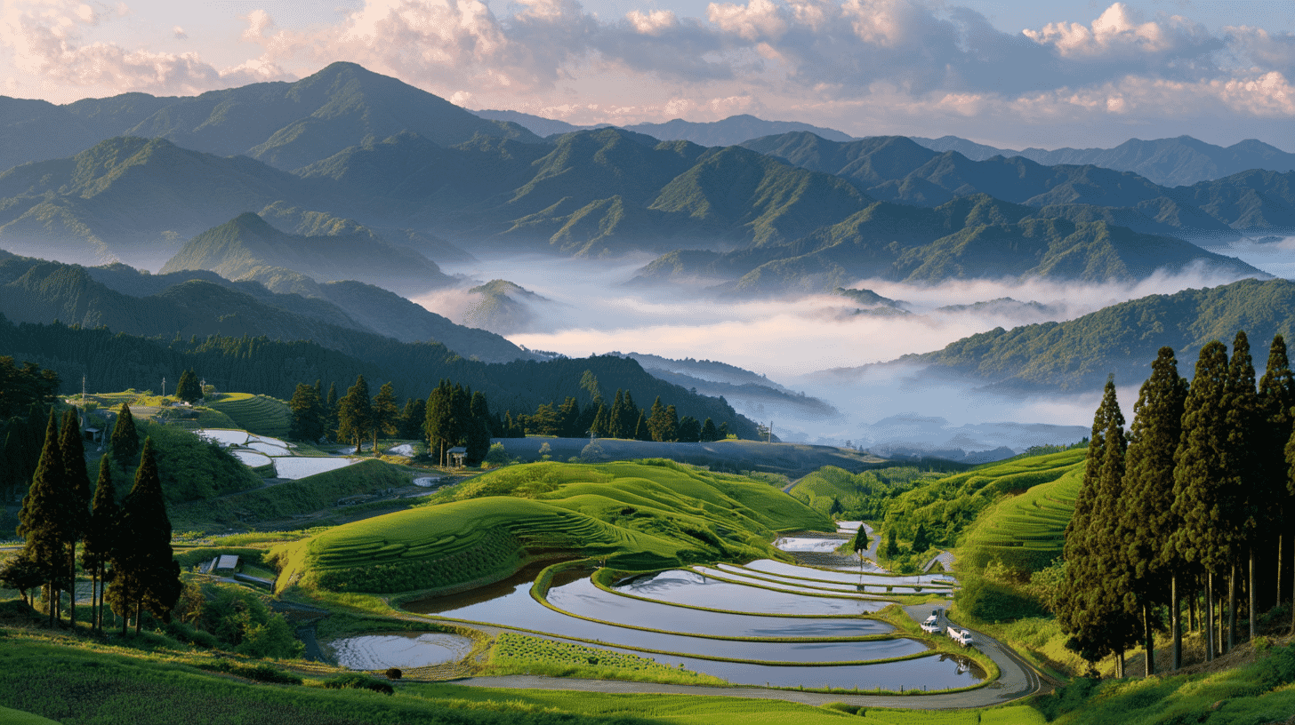
Ogi Tanada: The Fan-Shaped Terraced Rice Fields
Perhaps no single image better captures Ubuyama's cultural landscape than the Ogi Tanada—a remarkable terraced rice paddy system that spreads across the highland slopes like an opening Japanese fan. Located approximately 9 kilometers from the village office at an elevation of 820 meters, this photogenic site has been designated as one of Japan's Top 100 Terraced Rice Paddies and was recognized as a "Tsunagu Tanada Heritage" site in 2022.
Currently comprising 16 individual paddies—reduced from 59 paddies in the 1960s through consolidation efforts—the Ogi Tanada draws its water from Yamabuki Spring Source located 1.3 kilometers upstream. The pristine quality of this spring water, combined with the unique red volcanic soil and significant day-night temperature variations at this altitude, produces rice with a distinctive sweetness prized by local communities.
The visual appeal of Ogi Tanada changes dramatically with the seasons. During the planting season in late May and early June, water-filled paddies become perfect mirrors reflecting Mount Kuju, clouds, and even the Milky Way on clear nights. Summer brings vibrant green growth, autumn transforms the fields into golden expanses, and winter reveals the geometric patterns etched into the slope. Three tall cedar trees standing at the center of the terraces serve as iconic landmarks, framing photographs that have made this site famous among landscape enthusiasts.
Above the terraces, cattle graze freely on adjacent pastures, creating pastoral scenes that seem unchanged from centuries past. The terraces are maintained through a community agreement called the "Yamabuki Collective Agreement," which coordinates grass cutting, waterway maintenance, and the preservation of traditional practices.
Sacred Waters: The Spring Sources of Ubuyama
Water defines Ubuyama's landscape and culture. Two remarkable spring sources—Ikeyama Suigen and Yamabuki Suigen—represent the village's most treasured natural assets, both recognized in Kumamoto Prefecture's "100 Famous Springs" selection.
Ikeyama Suigen has earned national recognition as one of the Ministry of Environment's "100 Exquisite and Well-Conserved Waters of Japan." Located in a primeval forest grove surrounded by cedar trees estimated to be over 200 years old, this spring produces approximately 30 tons of crystal-clear water per minute at a constant temperature of 13.5°C. The water emerges through cracks in volcanic pyroclastic deposits from Aso's ancient eruptions, filtered over decades through underground aquifers before surfacing with remarkable mineral balance and purity.
The spring pool itself presents an almost ethereal scene—aquatic grasses wave gently in water so clear that small fish appear to float in air rather than swim in liquid. Moss-covered stones and ancient tree roots frame the spring, while shafts of sunlight filtering through the forest canopy create patterns of light and shadow that shift throughout the day. Visitors may collect water for personal use, and many make regular pilgrimages to fill containers with what locals consider some of Japan's finest drinking water.
Yamabuki Suigen, located closer to the Ogi Tanada terraces, offers a different but equally enchanting experience. A 10-minute walk through primeval forest from the parking area leads to this hidden gem, where 30 tons of water per minute bubble up through the forest floor to form an almost perfectly circular pool. The surrounding old-growth forest creates a mirror-like reflection on the water's surface, particularly striking when autumn leaves add splashes of crimson and gold. Water from this spring feeds directly into the Ogi Tanada terraces, maintaining the agricultural traditions that define Ubuyama's cultural landscape.
Both spring sources ultimately feed into the Ono River system, flowing eastward through Oita Prefecture before reaching Beppu Bay—a journey that connects Ubuyama's pristine highlands to the wider Kyushu waterscape.
Akaushi: The Red Cattle of Aso
No visit to Ubuyama's grasslands is complete without encountering the region's iconic Akaushi—brown-coated Japanese cattle that have been raised in the Aso region for centuries. These distinctive animals, officially classified as Japanese Brown cattle (Akage Washu), were developed through crossbreeding native Kumamoto cattle with Swiss Simmental cattle, creating a breed particularly well-suited to highland grazing.
Unlike conventional beef cattle raised in confinement, Ubuyama's Akaushi spend spring through autumn roaming freely across highland pastures, consuming 40-50 kilograms of wild grass daily while walking 5-8 kilometers across undulating terrain. This natural lifestyle produces exceptionally lean, flavorful meat with none of the excessive marbling that characterizes intensively raised wagyu beef.
The relationship between Akaushi and grassland maintenance is mutually beneficial—cattle consume grass that might otherwise require mechanical cutting, while their grazing pressure helps maintain the open character of the pastures. Traditional "summer mountain, winter village" (natsuyama fuyu-sato) practices see cattle brought down from highland pastures as winter approaches, spending the cold months in valley barns where they consume hay harvested from the same grasslands they grazed during warmer months.
Visitors can taste Akaushi beef at several local restaurants, including farmhouse establishments where the cattle were raised on-site. The meat's distinctive character—rich umami flavors developed through grass feeding, with a clean finish and no excessive fattiness—represents the edible expression of Ubuyama's sustainable agricultural traditions.
Seasonal Highlights and Best Times to Visit
Each season brings distinct experiences to Ubuyama's cultural landscape, and thoughtful visitors will plan their trips to coincide with specific natural phenomena or agricultural events.
Spring (March-May) offers the dramatic spectacle of noyaki wild burning, typically conducted between late February and early April depending on weather conditions. The controlled fires transform hillsides into seas of flame and smoke, creating photographic opportunities unlike anything else in Japan. Within days of burning, new grass shoots emerge to carpet the blackened earth in tender green, and by late April, cattle begin their annual migration to highland pastures. Late May brings the rice planting season, when water-filled terraces at Ogi Tanada become perfect mirrors.
Summer (June-August) sees the grasslands at their most lush and verdant. Higotai Park, located near the terraces, displays its namesake Higotai flowers in late July and August—spherical blue-purple blooms that have become Ubuyama's floral symbol. Morning mists frequently fill the valleys, creating atmospheric conditions that reward early risers with otherworldly landscapes.
Autumn (September-November) transforms the terraced fields into golden carpets as rice approaches harvest. The surrounding forests display spectacular foliage, with Yamabuki Spring Source particularly beautiful when maple leaves reflect in its still waters. Clear autumn skies offer the best conditions for photographing the Milky Way reflected in Ogi Tanada's flooded paddies.
Winter (December-February) brings a quieter beauty to Ubuyama. Snow occasionally blankets the highlands, creating monochromatic landscapes that reveal the underlying geometry of terraces and pastures. The spring sources continue flowing at constant temperature regardless of air temperature, and their steam rising into cold air adds a mystical quality to forest walks.
Surrounding Attractions
Ubuyama's position at the intersection of Aso-Kuju National Park's most scenic areas makes it an ideal base for wider exploration.
Ichiran-sanzan-dai (One-View-Three-Mountains Observation Point), located near Ubuyama Nursery School, offers panoramic views encompassing three of Kyushu's most famous peaks—Mount Aso, Mount Kuju, and Mount Sobo—all visible from a single vantage point on clear days. This remarkable viewpoint was named by the famous Meiji-era journalist Tokutomi Soho.
Higotai Park showcases highland wildflowers throughout the growing season, from spring Haru-rindo gentians through summer Higotai and autumn cosmos. The park includes interpretive facilities explaining the relationship between grassland ecosystems and traditional agricultural practices.
UBUYAMA PLACE offers locally-made cheese, wood-fired pizza, and park golf facilities against a backdrop of panoramic mountain views. The venue showcases products from Brown Swiss dairy cattle raised in the village—a more recent addition to Ubuyama's pastoral traditions that complements the longer-established Akaushi beef production.
The nearby Kurokawa Onsen hot spring resort, one of Kyushu's most atmospheric thermal bathing destinations, lies just 30 minutes by car. Visitors can combine cultural landscape exploration with traditional Japanese bathing experiences in this beautifully preserved hot spring village.
Getting There
Ubuyama's remote highland location requires some planning to access, but the journey itself passes through spectacular scenery.
By car from Kumamoto IC (Kyushu Expressway), follow Route 57 toward Aso, then continue via the Aso Panorama Line and local routes—approximately 90 minutes total. From Oita direction, the Yamanami Highway offers scenic access via Kuju Plateau.
Public transportation options are limited. The nearest JR stations are Namino or Takimizu on the Hohi Main Line, both approximately 10 kilometers from the village center. Since October 2024, "Ubuyama Noriai Bus" on-demand transportation operates within the village and connects to surrounding areas on designated days—advance reservation required through the "mobi" app system.
Rental car remains the most practical option for exploring Ubuyama's scattered attractions, and the driving itself offers constant rewards as the route winds through grasslands with ever-changing mountain views.
- 📍 Plan Your Visit to Kumamoto
- Find tours, activities & transport passes near Cultural Landscape of Aso / Rural Landscape of Ubuyama
- [ Kumamoto Castle & Mt. Aso Volcano Tours ]
Q&A
- Is there an entrance fee to visit the spring sources and terraced rice paddies?
- No entrance fee is required for Ikeyama Suigen, Yamabuki Suigen, or Ogi Tanada terraces. All are open year-round for free public access. Please respect posted guidelines—do not place hands, feet, or camera equipment in the spring water, as it serves as drinking water for local communities.
- When is the best time to photograph the terraced rice paddies?
- The most popular photography season is late May through early June during rice planting, when water-filled paddies create mirror reflections. Early morning and late evening offer the most dramatic light. Clear nights allow Milky Way photography reflected in the paddies. Note that drone photography is generally prohibited to avoid disturbing grazing cattle.
- Can I collect spring water to take home?
- Yes, water collection is permitted at designated areas near both spring sources. Bring your own containers—there are no supplies available on-site. The water requires no treatment and can be consumed directly. Many visitors specifically travel to Ubuyama to collect this renowned spring water.
- Are there restaurants serving local specialties in Ubuyama?
- Several options exist, including farmhouse restaurants serving Akaushi beef raised on-site, yamame trout cuisine at Ubuyama Suigyoen (raised in spring water), and UBUYAMA PLACE offering Italian-style dishes featuring local cheese. Some establishments require reservations, particularly on weekends.
- How accessible is Ubuyama for visitors without private transportation?
- Limited on-demand bus service connects to JR Namino Station and surrounding areas on specific days, but a rental car is strongly recommended. The village's attractions are scattered across highland terrain with limited pedestrian infrastructure. Cycling is possible for fit travelers, though routes include significant elevation changes.
Basic Information
| Cultural Property Name | Aso Cultural Landscape: Ubuyama Village Rural Landscape (阿蘇の文化的景観 産山村の農村景観) |
|---|---|
| Designation Category | Important Cultural Landscape (重要文化的景観) |
| Selection Date | October 13, 2017 (with additional selection March 20, 2023) |
| Total Area | 65.3 hectares |
| Location | Ubuyama Village, Aso District, Kumamoto Prefecture |
| Elevation | Approximately 600-900 meters |
| Contact | Ubuyama Village Planning and Promotion Division: 0967-25-2211 |
| Access | Approximately 90 minutes by car from Kumamoto IC; approximately 50 minutes from Kokonoe IC |
| Parking | Available at Ikeyama Suigen (30 vehicles), Yamabuki Suigen (15 vehicles), and Ogi Tanada (5-6 vehicles) |
| Admission | Free (all sites open year-round) |
References
- 文化遺産データベース - 阿蘇の文化的景観 産山村の農村景観
- https://bunka.nii.ac.jp/db/heritages/detail/409215
- 国指定文化財等データベース - 阿蘇の文化的景観 産山村の農村景観
- https://kunishitei.bunka.go.jp/bsys/maindetails/412/00004015
- 阿蘇を世界遺産に - 国選定「重要文化的景観」
- http://www.asosekaibunkaisan.com/property/landscapes/icl/
- 産山村公式サイト - 観光スポット
- https://www.ubuyama-v.jp/villagepromotion/996.html
- 熊本県観光サイト - 扇棚田
- https://kumamoto.guide/spots/detail/12481
- 阿蘇草原再生プロジェクト - 守り継ぐ草原
- https://www.asogreenstock.com/sougensaisei/see/inherit/
- 阿蘇地域世界農業遺産 - 続く草原
- https://www.giahs-aso.jp/value/grassland-maintenance/
- つなぐ棚田遺産 in KUMAMOTO - 産山村 扇棚田
- https://tanada-kumamoto.com/ougi.html
- 産山村観光協会 - 山吹水源
- https://ubu-lab.com/spot/山吹水源/
Last verified: 2026.01.27