
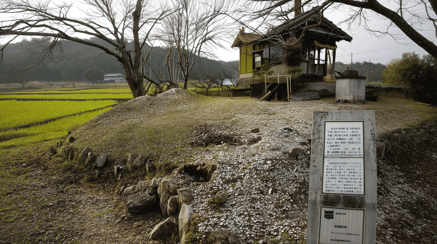
Shell Mounds, Designated in 1980
Ataka and Kurohashi Shell Mounds (阿高・黒橋貝塚, Adaka Kurohashi Kaizuka) are shell mounds at Jonan Town, Shimomashiki District, Kumamoto Prefecture, designated on 20 August 1980. The category is historic site, place of scenic beauty and natural monument.
The field for a managing body reads Jonan Town, with the date 19 November 1981. As with the Okichimozuku habitat, both the body and the date of its appointment are recorded.
The name sets two locations side by side. The Agency records that both were occupied continuously from the middle to the first half of the late Jomon period as a single site. Two names, one site.
A Filename Left Standing in the Commentary
The Agency's commentary opens with a string of characters.
It begins with a catalogue code, the two place names with their readings, and then a file extension followed by a colon.
The name of the document the text came from has been left at the head of the commentary.
Further on, the character for mound is replaced by a substitute mark with a footnote reference attached. The name field shows the character correctly; within the commentary it does not appear.
Traces of how the record was made remain in the record itself. The manner of writing has been a subject here throughout; a record showing its own making is new.
A Flood Uncovered the Site
The two locations were found in wholly different ways.
Of the first, the Agency records that the shell mound was discovered in 1916 during land readjustment work. It came to light in the course of levelling ground: a discovery by human hands.
The second was otherwise. In July 1972 the second mound came to light in the face of a paddy field scoured out by the torrent of the Hamado River in flood after heavy rain.
The river overflowed, cut into the paddy, and the deposit showed in the section. Nobody dug it. Water did.
Test excavation followed at the second location in 1973 and at the first in 1977. One waited a year from discovery to excavation; the other waited sixty-one.
The Centre Shifting over Time
The relation between the two locations is recorded as well.
As time went on, the centre of settlement shifted somewhat from the first location to the second.
The place where the same people lived moved gradually. The two locations are not separate sites but the track of one site in motion.
At Sashiki Castle Ruins, demolition was recorded in two stages. Here what is recorded is the process of a settlement moving.
The pottery is described too: marked with broad incised lines and wholly lacking cord impressions, the Ataka type of pottery is treated as the type specimen for the middle Jomon period in Kyushu. A place name has become the name of a pottery type.
Visiting
The site lies at Jonan Town, Shimomashiki District, Kumamoto Prefecture. The owner field is empty and the managing body is the town.
What was found is listed specifically: quantities of pottery and stone tools, together with more than fifty Jomon-period burials.
Among them, one mature woman was found with two bracelets of ark shell on her left arm, a case the record singles out. A single burial is described.
The shell layers are counted as well: thirty-seven kinds of shellfish including oysters and clams, fifteen kinds of fish including pufferfish and sea bream, along with wild boar, deer, dog, snake and frog. The number of species is given.
As an outdoor site, conditions for visiting differ from those for a building. Check the town's information before travelling.
Q&A
- When were the mounds designated?
- On 20 August 1980. They lie at Jonan Town, Shimomashiki District, Kumamoto Prefecture, and the managing body is the town, appointed on 19 November 1981.
- What is the string at the head of the commentary?
- The name of the document the text came from, with its file extension and a colon, left in place. The character for mound is also replaced by a substitute mark within the commentary, though the name field shows it correctly.
- How were they discovered?
- Differently. The first was found in 1916 during land readjustment work; the second came to light in July 1972 in the face of a paddy field scoured out by the Hamado River in flood after heavy rain.
- How are the two locations related?
- The Agency records that both were occupied continuously from the middle to the first half of the late Jomon period as a single site, and that the centre of settlement shifted somewhat from the first location to the second over time.
- What was excavated?
- Quantities of pottery and stone tools and more than fifty Jomon-period burials. The shell layers held thirty-seven kinds of shellfish and fifteen kinds of fish, along with wild boar, deer, dog, snake and frog.
Basic Information
| Name | Ataka and Kurohashi Shell Mounds (阿高・黒橋貝塚, Adaka Kurohashi Kaizuka) |
|---|---|
| Location | Jonan Town, Shimomashiki District, Kumamoto Prefecture |
| Designation | Historic site, place of scenic beauty and natural monument (historic site) |
| Year Designated | 1980 (20 August), designated |
| Quantity | No quantity field |
| Dimensions | The Agency records no dimensions. The site lies where the Hamado River runs out from hill country onto alluvial lowland, with one location on the right bank and the other on the left. The period runs from the middle to the first half of the late Jomon |
| Owner | The Agency's owner field is empty; the managing body is Jonan Town, appointed on 19 November 1981 |
| Public Access | An outdoor site; conditions for visiting differ from those for a building |
References
- Cultural Heritage Online: the Ataka and Kurohashi shell mounds
- https://bunka.nii.ac.jp/heritages/detail/173425
- Kumamoto City Museum
- https://kumamoto-city-museum.jp/162/188
- Agency for Cultural Affairs, National Cultural Properties Database
- https://kunishitei.bunka.go.jp/
- Agency for Cultural Affairs: introduction to monuments
- https://www.bunka.go.jp/seisaku/bunkazai/shokai/kinenbutsu/
Last verified: 2026.09.05