A Rare Window into Sengoku-Era Japan: The Echigo Province Kubiki District Map
Hidden within the prestigious Uesugi Museum in Yonezawa City, Yamagata Prefecture, lies one of Japan's most extraordinary cartographic treasures—the Echigo Province Kubiki District Map (越後国頸城郡絵図). Designated as a National Important Cultural Property in 2001, this magnificent hand-painted map offers visitors an unparalleled glimpse into late 16th-century Japan, capturing the landscape of Echigo Province (modern-day Niigata Prefecture) during the turbulent Sengoku period.
Unlike the standardized maps of the Edo period, this remarkable document retains the artistic sensibility of medieval Japanese cartography, presenting geographical information through beautifully rendered pictorial landscapes that blur the line between map and painting.
Historical Background: From the Uesugi Clan's Domain to Museum Treasure
The Echigo Province Kubiki District Map traces its origins to approximately 1597 (Keichō 2), during the reign of the legendary warlord Uesugi Kagekatsu. Based on backing paper inscriptions reading "Keichō 2, November 12" and the landholders' names recorded in the map corresponding to the period before Kagekatsu's transfer to Aizu domain in 1598, scholars have determined this date as the latest possible creation period.
The map was created following the cadastral surveys conducted between 1595 and 1597—first the Taikō Kenchi (land survey ordered by Toyotomi Hideyoshi) and subsequently the Uesugi clan's own domain survey. These comprehensive land assessments aimed to establish tax bases and clarify territorial boundaries, and this map represents their visual documentation.
The Uesugi clan brought this precious document with them when they were transferred to Yonezawa in 1601, where it remained in the domain treasury. In 1707 (Hōei 4), the map was discovered in severely damaged condition. Domain authorities immediately undertook restoration work and searched for maps of other districts, but none were found.
What Makes This Map a National Treasure?
The Echigo Province Kubiki District Map, together with its companion piece depicting Senami District (岩船郡), holds exceptional historical and artistic significance that warranted its designation as an Important Cultural Property.
First, these maps represent the only surviving examples of district-scale maps from the transition period between medieval and early modern Japan. While historical records confirm that Toyotomi Hideyoshi commissioned similar maps from all provinces, no other examples from this era have been discovered. The Kubiki and Senami district maps thus serve as the sole reference points connecting the cartographic traditions of medieval Japan with the systematized national mapping projects of the Edo period.
Second, the maps retain distinctively medieval characteristics that set them apart from later Edo-period cartography. The scale is not uniform throughout—a common feature of pre-modern Japanese maps where important locations might be depicted larger regardless of actual size. The landscape representation maintains a painterly, artistic quality, showing mountains, villages, and waterways with vivid colors and expressive brushwork rather than standardized symbols.
Third, the maps contain extraordinarily detailed administrative and demographic information. Beyond geographical features, they record village names, district boundaries (marked with red lines), landholders' names, standard tax yields (honnnō), surveyed crop yields (nawadaka), household numbers, and in the Kubiki map, even population figures. This wealth of data provides historians with invaluable insights into late 16th-century rural society, land ownership patterns, and local administration.
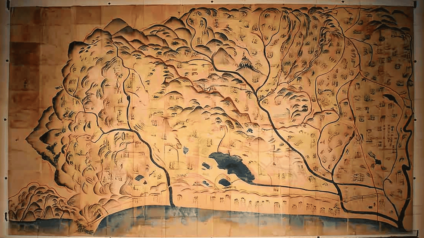
Visual Highlights: Reading the Landscape of 1597
Examining the Echigo Province Kubiki District Map reveals a remarkably detailed portrait of the region that was home to Uesugi Kenshin's legendary Kasugayama Castle. The map depicts the eastern portion of Kubiki District with extraordinary attention to both natural and human landscapes.
Castle fortifications appear as detailed architectural renderings, showing the strategic strongholds that defined territorial control during the Sengoku period. Villages and market towns are distinguished by their building styles, with coastal settlements depicted differently from inland agricultural communities. The road network connecting these settlements is clearly traced, offering insights into transportation routes and trade patterns of the era.
Temple and shrine complexes receive prominent placement, reflecting their importance as cultural and administrative centers in medieval Japan. Agricultural lands—the economic foundation of samurai domains—spread across the map in varying shades of green, while the water systems including rivers, irrigation channels, and coastal waters are rendered in blue.
The mountain ranges framing the district are painted with remarkable expressiveness, capturing the dramatic topography of what is today known as the Kubiki Plain (頸城平野), bounded by mountains and facing the Sea of Japan.
The Uesugi Legacy: Guardians of Cultural Heritage
The preservation of the Kubiki District Map is inseparable from the remarkable cultural stewardship of the Uesugi clan. Originally ruling Echigo Province from Kasugayama Castle, the Uesugi were renowned not only as fearsome warriors but as patrons of arts and learning.
Uesugi Kagekatsu, under whose administration this map was created, was the adopted son and successor of the legendary Uesugi Kenshin. After the upheaval of the Sekigahara conflict in 1600, Kagekatsu was transferred to Yonezawa with a dramatically reduced domain of 300,000 koku. Despite this setback, the Uesugi maintained their commitment to preserving their cultural heritage, bringing with them documents, artworks, and artifacts accumulated over generations.
This dedication to cultural preservation explains why Yonezawa's Uesugi Museum today houses an extraordinary collection of Important Cultural Properties and National Treasures, including the famous "Rakuchū Rakugai-zu" folding screens painted by Kanō Eitoku—a gift from Oda Nobunaga to Uesugi Kenshin.
Visiting the Uesugi Museum
The Echigo Province Kubiki District Map is housed at the Yonezawa City Uesugi Museum (米沢市上杉博物館), part of the "Denkoku no Mori" cultural complex adjacent to the Uesugi Shrine and Matsugasaki Park—the site of the former Yonezawa Castle.
The museum's permanent exhibition traces the history and culture of the Uesugi clan, with rotating displays of its extensive collection. Due to conservation requirements, specific items including historical documents may not always be on public display. Visitors interested in viewing the Kubiki District Map specifically are encouraged to contact the museum in advance regarding current exhibition schedules.
The museum building itself is a striking example of contemporary architecture, providing a fitting home for these irreplaceable cultural treasures. Multilingual support is available, making the museum accessible to international visitors.
Exploring the Region: Where the Map Comes to Life
For visitors wishing to connect the historical map with today's landscape, the Kubiki District depicted in the map corresponds to present-day Jōetsu City in Niigata Prefecture. This region offers numerous attractions that bring the map's world to life.
Kasugayama Castle Ruins stands as the most significant historical site in the region. Once the residence of Uesugi Kenshin and later Uesugi Kagekatsu, this mountaintop fortress is designated a National Historic Site and ranked among Japan's Top 100 Castles. The castle ruins offer panoramic views of the Kubiki Plain and the Sea of Japan—the very landscape depicted in the 1597 map.
The Jōetsu City Buried Cultural Property Center and Kasugayama Castle Monogatari-kan provide excellent context for understanding the region's Sengoku-era history. Rinsen-ji Temple, where Uesugi Kenshin studied as a youth, preserves the gate said to have been transferred from Kasugayama Castle.
The journey between Yonezawa (where the map is preserved) and Jōetsu (where the map's landscape exists) itself traces a historic route of Uesugi domain transfers, offering travelers a deeper appreciation for the cultural connections between these regions.
Planning Your Cultural Heritage Journey
A visit combining the Uesugi Museum in Yonezawa with the Kasugayama Castle area in Jōetsu creates a comprehensive cultural heritage experience spanning both the document and its subject landscape.
From Tokyo, Yonezawa is accessible via the Yamagata Shinkansen in approximately 2 hours. The Uesugi Museum is a short bus ride or 20-minute walk from Yonezawa Station. Jōetsu City is reachable via the Hokuriku Shinkansen to Jōetsu-Myōkō Station.
Spring and autumn offer ideal visiting conditions, with pleasant weather for castle ruins exploration and beautiful seasonal scenery. The annual Uesugi Festival in late April through early May brings historical reenactments and celebrations to Yonezawa, while the Kubiki region offers stunning views of rice paddies that echo the agricultural landscape documented over four centuries ago.
- 📍 Plan Your Visit to Yamagata
- Find tours, activities & transport passes near Map of Kubiki County, Echigo Province
- [ Yamadera Temple & Zao Onsen Hot Springs ]
Q&A
- What exactly is the Echigo Province Kubiki District Map?
- It is a large hand-painted cartographic document created around 1597, depicting the Kubiki District of Echigo Province (now part of Niigata Prefecture). The map shows castles, villages, temples, roads, farmland, rivers, and mountains in vivid colors, along with detailed annotations including village names, landholders, tax records, and population data. It was preserved by the Uesugi clan and is now designated as a National Important Cultural Property.
- Why is this map considered so valuable?
- The Kubiki District Map is the only surviving example of a district-scale map from the late 16th century transition period between medieval and early modern Japan. It bridges the gap between medieval cartographic traditions and standardized Edo-period mapping, while providing irreplaceable historical data about Sengoku-era society, land administration, and geography.
- Can I see this map at the museum anytime?
- Due to conservation requirements, historical documents including the Kubiki District Map may be displayed on a rotating basis. The museum holds the map and its companion pieces, but specific items are not always on public view. Contact the Uesugi Museum directly to inquire about current exhibition schedules before your visit.
- What is the connection between the Uesugi clan and this map?
- The map was created during the rule of Uesugi Kagekatsu over Echigo Province, likely as documentation of land surveys conducted in 1595-1597. When the Uesugi were transferred to Yonezawa in 1601, they brought this map with them. It remained in the domain treasury until its rediscovery in 1707 and has been preserved by the Uesugi family's cultural legacy ever since.
- Can I visit the actual region depicted in the map?
- Yes! The Kubiki District corresponds to present-day Jōetsu City in Niigata Prefecture. Key sites include Kasugayama Castle Ruins (Uesugi Kenshin's former stronghold), Rinsen-ji Temple, and the surrounding Kubiki Plain. Visiting both Yonezawa (to see the map) and Jōetsu (to see the landscape) creates a complete cultural heritage experience.
Basic Information
| Name | Echigo Province Kubiki District Map and Senami District Map, with Attached Echigo Province Map (越後国頸城郡絵図・越後国瀬波郡絵図 附 越後の国絵図) |
|---|---|
| Cultural Property Designation | National Important Cultural Property (Historical Materials) |
| Designation Date | June 22, 2001 (Heisei 13) |
| Period | Azuchi-Momoyama Period (ca. 1597) |
| Repository | Yonezawa City Uesugi Museum (米沢市上杉博物館) |
| Owner | Yonezawa City |
| Museum Address | 1-2-1 Marunouchi, Yonezawa City, Yamagata Prefecture 992-0052 |
| Museum Hours | 9:00 AM - 5:00 PM (Last entry 4:30 PM) |
| Closed | 4th Wednesday (Apr-Nov), Every Monday (Dec-Mar), Year-end/New Year holidays |
| Admission (Permanent Exhibition) | Adults ¥410, High school/University ¥210, Elementary/Junior high ¥110 |
| Access | Bus from JR Yonezawa Station to "Uesugi Jinja-mae," or approximately 20 min walk |
| Official Website | https://www.denkoku-no-mori.yonezawa.yamagata.jp/ |
References
- 山形の宝検索navi - 越後国頸城郡絵図
- https://www.pref.yamagata.jp/cgi-bin/yamagata-takara/?m=detail&id=1102
- 文化遺産オンライン - 越後国頸城郡絵図
- https://bunka.nii.ac.jp/heritages/detail/202623
- 国指定文化財等データベース - 越後国頸城郡絵図
- https://kunishitei.bunka.go.jp/bsys/maindetails/201/10501
- 伝国の杜 米沢市上杉博物館
- https://www.denkoku-no-mori.yonezawa.yamagata.jp/uesugi.htm
- 東京大学史料編纂所 - 越後國郡繪圖一 頸城郡
- https://www.hi.u-tokyo.ac.jp/publication/syoho/18/pub_echigo-01/
- 上越観光Navi - 春日山城跡
- https://joetsukankonavi.jp/spot/detail.php?id=133
Last verified: 2026.01.27